Long-O weekend 2012
29/30 September, Dunster & Exmoor
Dunster Forest
Credit:
Steve Winkley
Day 1 - Croydon Hill, Dunster Woodlands
Completing the QO Long-O weekend together as part of our pre-OMM training (or in my case pretty much my only pre-OMM training!) is becoming a bit of a tradition for Richie Hill and I. Last year I was left limping after Day 1 and was a ‘DNS’ for Day 2, so this year I was determined to at least last the whole weekend.

Credit: at OMM
It didn’t start well as we got stuck in traffic diverting around an accident on the A358, so we were a bit late getting to the event. But at least Day 1 was the score event, so unless we really messed up we’d be back in 3hrs. And on the plus side, the sun was shining and conditions underfoot were pretty good—in fact it was a perfect day for a run in the woods.
He couldn’t find his dibber...the words ‘needle’ and ‘haystack’ sprang to mind...
Croydon Hill made for a fine setting and we had a really enjoyable run. The only ‘panic’ came when Richie stopped to sort out the onset of a blister (he was breaking in his new O-shoes at this event!) and then realised at the next control that he couldn’t find his dibber. The words ‘needle’ and ‘haystack’ sprang to mind as I tried to think of where exactly in the middle of a large patch of ’rough open’ we’d stopped, only for a very relieved Richie to realise that he’d popped it in the pocket of his backpack. Phew!
Richie had told me on the way down to the event that I was going to be ’lead navigator’ this weekend—about three hours later he was probably regretting it. I decided to take us on a pretty direct route that would take us down the side of a hill marked as ‘rough open’ on the map, and then along the road for a bit. It sounded like a fast and easy option...until we saw the ’rough open’ in question... A vast swathe of Rhododendron (and yes—I did have to look up the spelling!) bushes had been cut down on the hillside and left where they fell. The result was a challenging obstacle course—a bit like climbing a giant tree, but horizontal rather than vertical. We were walking along the tops of the dead bushes about 4ft off the ground, trying our hardest not to go crashing through. I did actually manage to get my leg well and truly stuck at one point before we eventually made it to the bottom of the hill. Well how was I to know?!
I managed to get a 2 point deduction for finishing 4 seconds later—I’d have ’dipped for the line’ if I’d known!
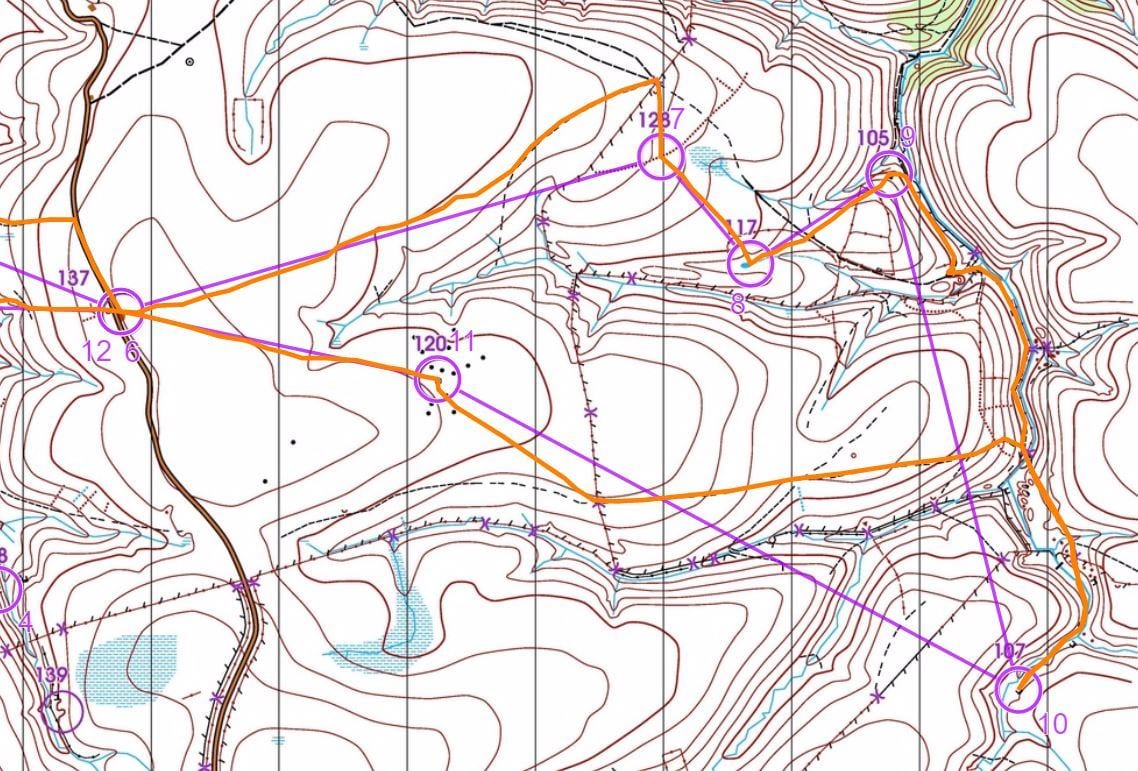
I did atone for the Rhododendron challenge by spotting the permitted route through the out-of-bounds area in the centre of the map that I gather some competitors missed, and overall I was pretty pleased with our efforts. Richie finished 5th with 328 points whilst I was 6th with 326 points—yep, I managed to get a 2 point deduction for finishing 4 seconds later—I’d have ’dipped for the line’ if I’d known! The tracking software programme on my iPhone showed we had covered 9.5 miles, and when I looked at the map later we’d also made what looked like a decent attempt at drawing the outline of Africa!
Credit: Routegadget
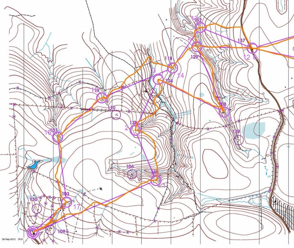
Day 2 - Pinkery and Central Exmoor
Richie spent the journey down telling me horror stories of man-eating swamps and tussocks the size of tombstones...
I’d never run at Pinkery before, and Richie spent the journey down telling me horror stories of man-eating swamps and tussocks the size of tombstones that he’d encountered on a previous Long-O event there. It had also turned a lot colder, adding to the feeling that Day 2 was going to be a tougher challenge. Still, at least it wasn’t raining...
Sure enough the terrain proved to be hard work as we made our way to the very first control, and it didn’t get much easier until we crossed the road to the east. The route from control 9 to 10 was very much the exception—a chance to get some speed up running down a hard and relatively flat track at the bottom of a valley. Just as I was getting used to it the track ended and we were knee-deep in freezing cold water as we had to make one of several stream crossings.
As we made our way over the top of a hill and past some of the most ‘ruined’ ruins I have ever seen the weather started to take a turn for the worse, and I knew that we’d soon be crossing the road and heading back through the ‘chains’. I must admit that the thought did not fill me with happiness. Still, we ploughed on (quite literally in some cases!) and I broke out my emergency morale-boosting pack (a bag of jelly babies).
I was starting to daydream about a hot bath and a nice cup of coffee
The final control proved to be one of the most difficult of all—the navigation was easy enough (follow a bearing to a fence crossing then pick up a fence line for a while), but boy was it boggy! I seemed to sink up to my knees every few steps, and it was becoming a real effort to pull my legs out each time. By this point it was properly raining as well, and I was starting to daydream about a hot bath and a nice cup of coffee. Still, the end was in sight (or would have been if the visibility was better), and we made our way downhill to the finish.
Our time of 5hrs 51mins put us down in 12th or 13th place, but at least we’d finished the course and could enjoy the legendary soup and cakes that are always a welcome feature of the Long-O weekend. We’d covered 16.9 miles on Day 2, bringing our total for the weekend to 26.4 miles and 6,765ft of asecent (equivalent to two ascents of Snowdon). At least Richie’s new O-shoes had been broken in, and the day-glo yellow had turned a demure shade of dark brown.
Adrian Edwards
QuOnicle 146, November 2012