Open source maps
"Open Orienteering Maps"
Produced in Open Orienteering Maps
We use these maps when there is no bespoke OCAD map for an area- so every where except certain parts of Taunton. They are produced from open source mapping data. This article explains the difference in the specification of the two types of map used.
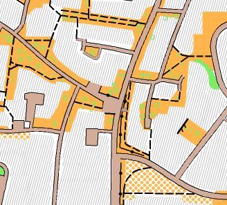
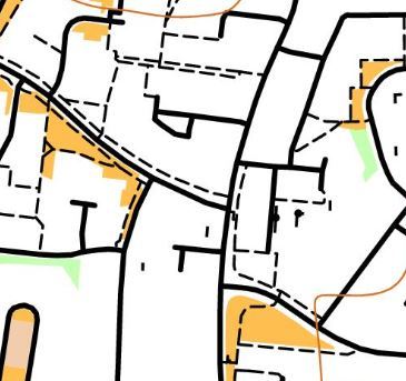
The two map excerpts pictured show the same part of Pyrland, Taunton. One is mapped in OCAD and the other is in Open Orienteering Maps ("O-Maps").
OCAD
Traditionally, maps have been produced in OCAD, to a high specification, displaying individual trees, accurate road widths and on some maps individual buildings and pavements are shown.
Open Orienteering Maps
O-Maps obtains its data on a nightly feed from Open Street Maps ("Street Maps"). Street Maps is a global open-source mapping project with a whole variety of contributors.
Map amendments are best made in Street Maps. But it varies from very easy to almost impossible to show certain features on the O-Map, depending what they are! Although O-Maps tend to be more basic than OCAD maps as a consequence, with sensitive updating they can be nearly as effective.
What they show
Man-made features shown: roads, paths, bridges, car parks, tall walls.
Natural features shown: open land, woods, hedges, ponds, streams & rivers, substantial earthworks, contours.
Rough open and grass are shown in their standard colours of magnolia and orange respectively.
Everything else is shown in white. As this tends to be private property, 'white' is out of bounds. Private grass and parking bays etc will be shown in white.
O-Maps often show walls that are of no consequence to navigation, lending a clutter to the map. They should not be confused with footpaths. This applies particularly in poor light or at speed.
What tends to be omitted
- Runnability of woods- there is only one colour, a light shade of green
- Presence of undergrowth
- Individual trees
- Private roads, driveways and access paths
- Earth features, unless substantial
- Fences
- Low walls
- Ditches
- Gates
- Cut throughs, underpasses and tunnels
- North lines
NB- the mapper might be able to add some of these onto the event map using Purple Pen
Although fences etc are omitted, they will be part of the white areas on the map which are out of bounds and hence not crossable.
Gateways are usually shown by either a path or a crossing point symbol.
Advantages
- Free, open source, geo-referenced.
- Basic maps for all the UK.
- Less time-consuming to produce something workable.
Disadvantages
- Walls affect map clarity - even short walls on private property are mapped. This affects the maps' legibility.
- Lack of fences - which could form a boundary
- Lack of features to 'hang' controls on. But as the most convenient GPS control is a lamp post, MapRunners get used to not seeing a control feature on the map.
- Omitted features- there are often many, which can take hours to find and update. Maps are works-in-progress.
For the organisers:
- Lack of ownership / control of the map data
- Inability to override mapping conventions of the software