Getting started
MapRun
MapRun
The following is information common to all MapRun courses that we have set up.
Information resources
Your first port of call should be our MapRun User Guide.
Please also browse through the official site - it has a lot of information that we do not have space for here.
Preparation
Obtain a smartphone with a GPS chip (even £40 phones may have one). See MapRun website for specifics.
Download the MapRun app onto a smartphone. NB: we are no longer using the MyOMaps app.
Consider investing in an armband for your phone to keep it safe. Wear it on the inside of your wrist so you can see status updates while you're on the move.
Some events are protected by a four-digit PIN code- if it is, please contact the organiser for one.
If you're running at an unmanned event, you need to print a copy of the course map- no peeking before you start, though!
Then load the event onto the MapRun app. First point the app to the MapRun server (via Settings). The interface will then allow you to choose an event. Go into the MR UK folder then MR Quantock Orienteers.
When choosing your footwear, bear in mind if taking a shortcut across parkland it may be slippy, muddy and sometimes may be overgrown.
Phone settings
Before you start you will need to make sure the GPS function on your phone is enabled. For iPhones, go to 'Settings' then 'Privacy' and make sure 'Location Services' is switched on (Android phones might be slightly different).
You may also want to temporarily alter your Display setting so that your phone doesn't switch to Autolock during your run (this is not essential, as MapRun will still run in the background even if the screen goes to Autolock). For iPhones go to 'Settings' then 'Display & Brightness' then 'Autolock' and select 'Never'.
If you do change this setting remember to change it back again after your run.
Base / parking
Courses tend to have a convenient base and Start and Finish location.
Where possible, these have been sited next or near to public parking or shoppers' parking areas. If you are not making purchases from traders, there will often be residential streets to park in nearby.
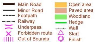
The map
This can be in either OCAD or OOM format:
OCAD maps
These are highly detailed, often with individual trees mapped.
OOM (Open Orienteering Maps)
- are generic and freely obtained online, with less detail.
- uses a standard set of symbols: see illustration.
Start and Finish
Where possible, these are located on a prominent feature such as a big sign, a post box or a gateway.
Once you have activated the GPS, loaded the event, and started the event on your phone you are ready to go to the Start. As at all control points, your phone will recognise the Start location when you get within a few metres of it and you will hear a buzz from it.
Sometimes the app registers you as starting before you've even reached the Start. Try to let the GPS 'settle down' i.e. give it a chance to locate the satellites accurately before going near the Start. If you have a false start, just end your run and try again.
Don't go near the Finish till you actually want to finish, otherwise your run will automatically end.
Scoring
Try to score as many points as possible within each course's time limit.
Far away or trickier controls score more than easier ones or those near the Start / Finish.
Courses use one of three scoring systems.
Each course is to a set time limit.
Exceed this limit and there are penalties; points will be deducted per minute or part minute that you overrun.
Don't worry if you're not especially competitive or fancy taking your time. You will still get a raw points total (before penalties) and you don't have to upload your result to the Leaderboard if you don't want to.
Scoring systems
The simplest system uses an equal points value for all controls (used by our Summer Series 2018)
An alternative system we have used is controls score points based on their own number value, as follows:
| Controls | Points value each |
|---|---|
| 10 - 19 | 10 |
| 20 - 29 | 20 |
| 30 - 39 | 30 |
Safety and course suitability
There can be occasionally some fairly major roads to cross, so take particular care crossing these, and of course be aware of traffic on all of the roads around the area. Suitable crossing points are marked on the map where they exist on the busier roads.
If running the course in twilight or dark, you must wear a head torch and a top with fluorescent piping at the minimum and preferably a high viz vest or jacket.
Also, remember that some courses contain a variety of underpasses and alleyways- you may want to pair up.
The map cannot be expected to be up-to-date at all times, therefore please proceed with caution - there may be unexpected developments, road works or barriers to access throughout the course.
The courses are not open to participants under the age of 16, unless accompanied by an adult.
All participants are responsible for their own safety.
You must read the user agreement before taking part in any of our courses:
Troubleshooting?
Experiencing an unreliable signal? Try the following:
GPS advice by Strava
Signal accuracy varies between phones, as does location and the degree of cloud cover. If your GPS is slow or inaccurate, you will be credited with controls you narrowly miss. Just move on to the next control.
Photo Gallery
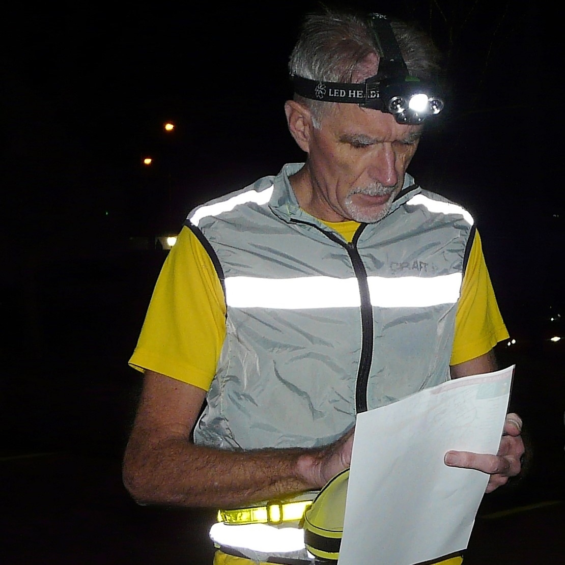
Credit: Judy Craddock